(Link zur Deutschen Version / Link to the German Version)
Overview
In the “Valentin-3D” project, the Memorial U-boat Bunker Valentin in Bremen, Germany is digitized by air, ground and underwater robots. Different processes and methods are being used for this. Aerial photographs are collected from videos from an Unmanned Aerial Vehicle (UAV) for the exterior area, which are processed with photogrammetry for 3D modeling. Laser scans are predominantly used in the indoor areas. They get integrated into 3D maps with registration and Simultaneous Localization and Mapping (SLAM). For underwater areas, drones with cameras using light projection techniques as well as sonar are used. Challenges for the digitization of the bunker include the size of the object with areas that are sometimes difficult or impossible for humans to access, the presence of repetitive structures due to the use of, among others, casting templates and standard parts during construction, and the presence of large underwater areas that are difficult to access.
The project is an interdisciplinary cooperation of robotics and contemporary history at Constructor University. It is supported by the German Federal Ministry of Education and Research (BMBF) within the funding program digital exploitation of cultural heritage (eHeritage).
Background
The submarine bunker “Valentin” was built from 1943 to 1945 with massive use of forced laborers. The bunker was the largest armament project of the German navy and it was supposed to function as a submarine shipyard for them. The plan was to produce Type-XXI submarines, but this did not happen because the bunker could not be completed before the end of World War II. Up to 12,000 forced laborers worked on the bunker construction site every day, and many of them lost their lives. 1,700 deaths were recorded, though estimates range from as many as 2,000 to 6,000 dead. Most of the workers were housed in various camps around the bunker in mostly inhumane conditions.
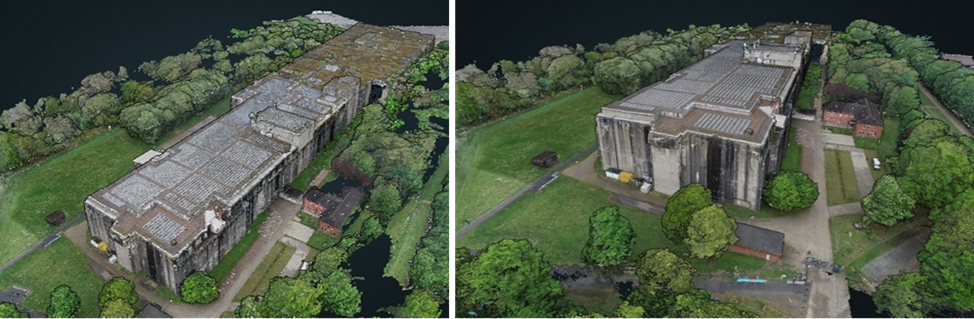
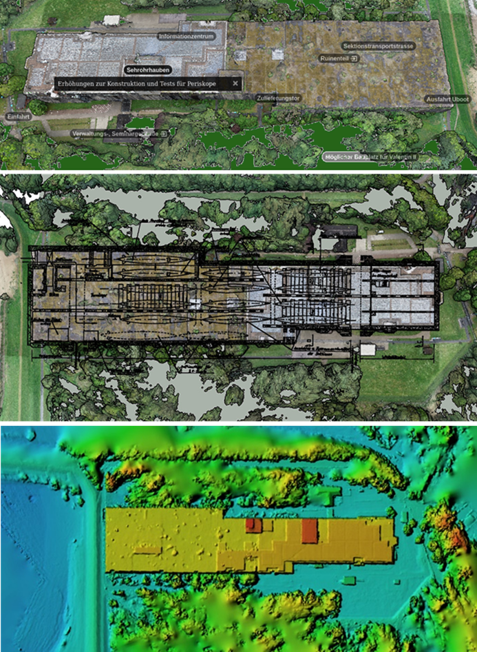
The bunker has a length of 426 meters, a width of 67 meters (east) to 97 meters (west) and a height of 30-33 meters. With its floor area of 35,375 m2, it is the largest free-standing bunker in Germany and the second largest in Europe after the submarine bunker in Brest, built in occupied France. The interior, secured with 7 m thick ceiling concrete and 4.5 m thick exterior walls, contains 520,000 m3.
There were various camps in the vicinity of the bunker from which the forced laborers were brought to the construction site on a daily basis or reached the bunker via the so-called camp road. These included, for example, a barracks camp of the navy for Soviet prisoners of war, a labor education camp of the Bremen Gestapo, the Farge concentration camp, which was a subcamp of the Neuengamme concentration camp, and a camp for the marine soldiers assigned to guard the prisoners.
Results
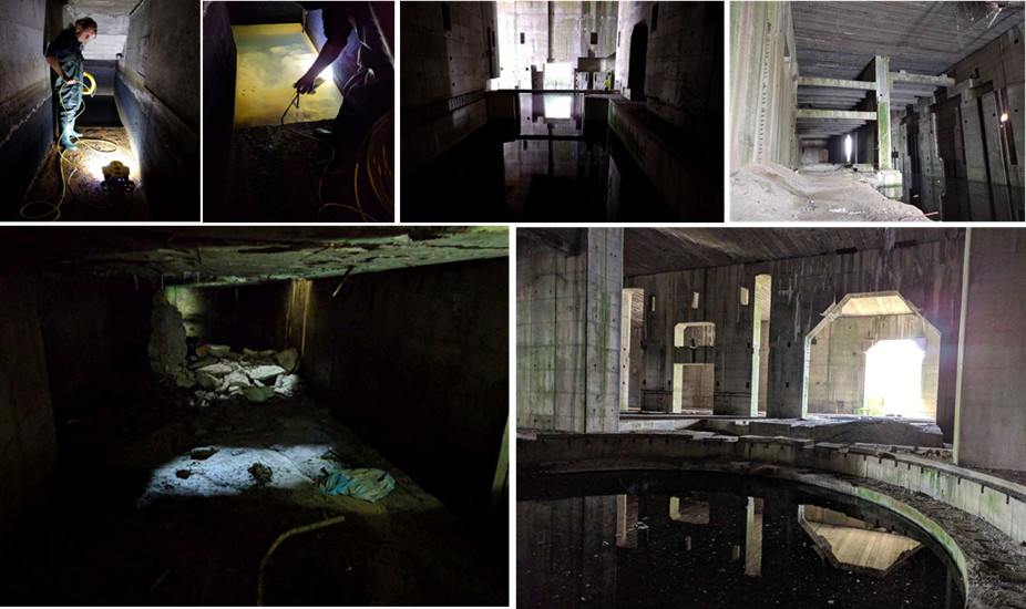
Digitization Planning and Raw Data Collection
As a part of the planning of the collection of the data, construction plans of the bunker were viewed and digitized. Based on this, the actual raw data is collected, i.e. aerial photographs in the form of 2D video by an Unmanned Aerial Vehicle (UAV), recordings of the interior in the form of 2.5D RGBD laser scans and photographs of the underwater areas by an Umanned Underwater Vehicle (UUV). In the first phase of the project, a main focus was on the acquisition of overview data, which was complemented later on by more detailed data.

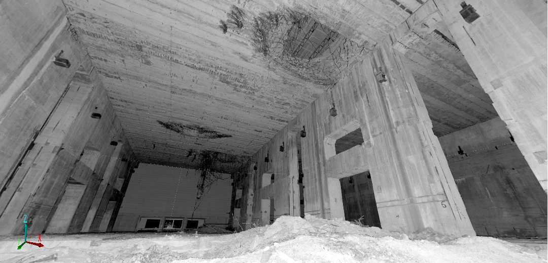
3D Modelling
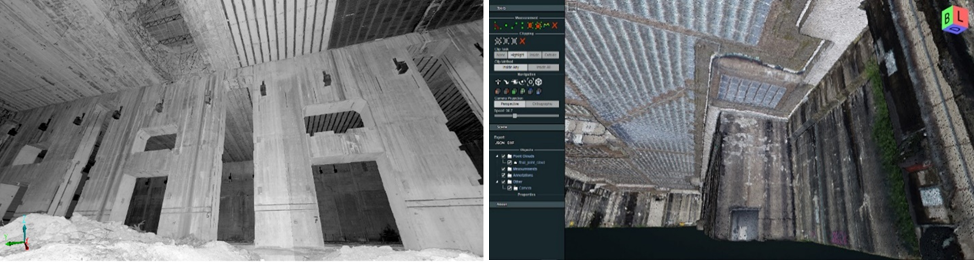
Detailed 3D models (of parts) of the bunker are created in the project. In addition to standard procedures and tools, own contributions and methods from other research projects are used to deal with some special challenges of the bunker. The data and models obtained in the project are designed to be processed and analyzed using open free software to allow third parties to access everything with as few barriers as possible.
The available data allow various forms of analysis, or representation of structural and historical aspects and hypotheses. These include, for example, semantic annotations regarding the intended function of structural features, overlays with digitized construction plans or measurements.
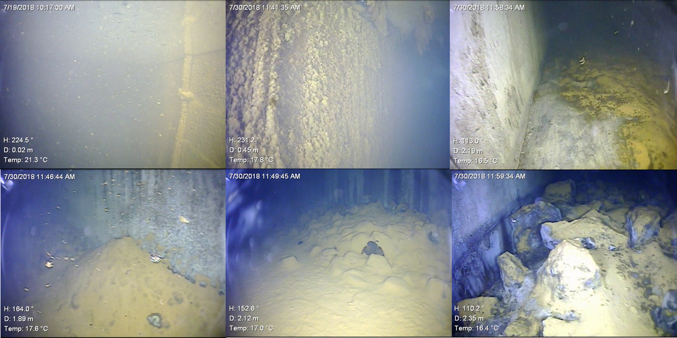
A special feature in the project is the use of robots to explore the inaccessible underwater areas. These include basement areas for which it is unclear why they are extensively flooded, i.e. whether this was deliberately initiated – e.g. by the Allied Forces or later by the German Bundeswehr, e.g. through openings or breakthroughs, or whether it was due to structural defects or planning errors.
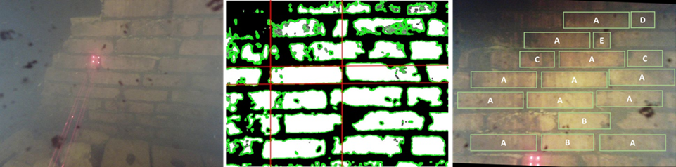
Due to poor visibility in these areas, mapping with sonar is necessary for orientation. Using a light projection method, it was, e.g., possible to measure the bricks of walls in the flooded basement. Given the changes in brick size standards in Germany after World War II, this information provides some indication when the walls were built, as they are predominantly bricks in the so-called Oldenburg format, which was in use before the end of World War II.
Symposium
The Symposium “Zeugnisse des Nationalsozialismus, digital – Projekte, Methoden, Theorien” was held in December 2019 at Constructor University. Information about the symposium can be found here (in German). The proceedings of the symposium are in English. The book “Writing the Digital History of Nazi Germany: Potentialities and Challenges of Digitally Researching and Presenting the History of the ‘Third Reich’, World War II and the Holocaust” is Open Access and available at https://www.degruyter.com/document/doi/10.1515/9783110714692/html.
Publications
Following project-related publications appeared so far:
[1] H. Bülow, C. A. Müller, F. Buda, A. G. Chavez, and A. Birk, “A Divide and Conquer Method for 3D Registration of Inhomogeneous, Partially Overlapping Scans with Fourier Mellin SOFT (FMS),” in IEEE International Conference on Robotics and Automation (ICRA), 2020. https://doi.org/10.1109/ICRA40945.2020.9197453 [Preprint PDF]
[1] T. Julia and B. Frederike, Eds., “Writing the Digital History of Nazi Germany“. Berlin, Boston: De Gruyter, 2022. https://doi.org/10.1515/9783110714692 [Open Access]
[3] A. Birk, F. Buda, H. Bülow, A. G. Chavez, C. A. Müller, and J. Timpe, “Digitizing a Gigantic Nazi Construction: 3D-Mapping of Bunker Valentin in Bremen,” in Writing the Digital History of Nazi Germany, De Gruyter, 2022, pp. 133-168. https://doi.org/10.1515/9783110714692-006
[4] T. Julia and B. Frederike, Eds., “Writing the Digital History of Nazi Germany“. Berlin, Boston: De Gruyter, 2022, p.^pp. Pages. https://doi.org/10.1515/9783110714692
[5] A. Birk, F. Buda, and T. Hansen, “Dating Wall Constructions from Brick Sizes in the Flooded Basement of a WW-II Submarine Bunker for the Digitization of Cultural Heritage,” in MTS/IEEE OCEANS, Limerick, 2023. https://doi.org/10.1109/OCEANSLimerick52467.2023.10244268 [Preprint PDF]
[6] T. Hansen and A. Birk, “Using Registration with Fourier-SOFT in 2D (FS2D) for Robust Scan Matching of Sonar Range Data,” in IEEE International Conference on Robotics and Automation (ICRA), 2023. https://doi.org/10.1109/ICRA48891.2023.10160519 [Preprint PDF]
[7] T. Hansen and A. Birk, “Synthetic Scan Formation for Underwater Mapping with Low-Cost Mechanical Scanning Sonars (MSS),” IEEE Access, vol. 11, pp. 96,854-96,864, 2023. https://doi.org/10.1109/access.2023.3312186 [Open Access]
[8] T. Hansen, F. Buda, and A. Birk, “Underwater Exploration with Sonar of the Flooded Basement of a WW-II Submarine Bunker in the Context of Digitization of Cultural Heritage,” in MTS/IEEE OCEANS, Limerick, 2023, pp. 1-5. https://doi.org/10.1109/OCEANSLimerick52467.2023.10244377 [Preprint PDF]
Use of the Data
The data generated in this project is freely available for research under a Creative Commons Attribution-NonCommercial (CC BY-NC) license. An overview and access to the data is provided here. Please keep the historical context of the bunker in mind when using the data.